
Regular readers of our blog may remember that we reopened Pit 20 at the end of 2014 and extended the original pit along the line of the massive beam we had found at a depth of some 1.5m below the present ground surface, at the time uncovering a length of 2m in total. At the time, member Mike Gill produced a stunning 3D model of the surface of the beam from a series of photographs. We had partially filled in the extended pit during 2015 while awaiting a suitable opportunity to investigate further. In the last few weeks we have returned to Pit 20 and re-exposed the beam, increasing the exposed length to over 3m. We are in the process of sampling the newly exposed beam, west of the scarf joint we have discovered joining two pieces of the beam in what seems to be an extension or repair. The western segment of the beam appears much more eroded and more crudely finished that the easternmost segment which dendrochronology has dated to a felling date of 1282AD.
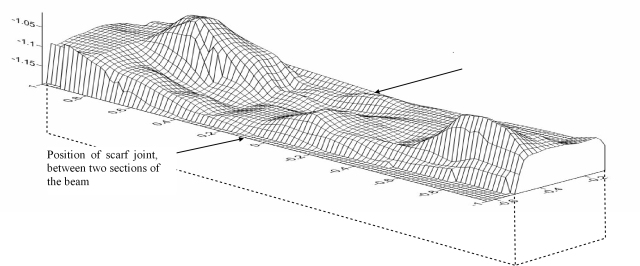 We are also working to record the beam profile, hindered as usual by the wet conditions in the pit which invariably has to be pumped out whenever we return to it, and regularly baled out during the working day. One of the interesting methods we have investigated, using open source software called Meshlab, involves calibration of the 3D model by means of the measuring scale included in the photograph and then producing a series of profiles across the beam. The end result can be a scaled wireframe model as shown in the accompanying figure (the scales are in metres, with an arbitrary datum in the xyz axes). Unfortunately the water surface obscures many of the less distinct features of the top of the beam, but the technique shows promise for the amateur archaeologist without access to high tech scanning equipment as means of recording complicated structure.
